


Tucked away amongst farm fields, silos, and sometimes migrating geese sits a natural wildlife reserve along the waterways where the Skagit River meets Skagit Bay. Situated here, on the southeast corner of Fir Island, is Wiley Slough, a prime wildlife and birding area managed by the Washington Department of Fish and Wildlife (WDFW). If you are a nature lover, birder or photographer, grab your gear and take a walk at Wiley Slough.
As the Skagit River flows out towards the Salish Sea it divides into a network of channels, sloughs, marshes and even bogs. These waterways not only control the flow of water, filtering it as it makes its way towards Skagit Bay, they also provide the perfect habitat for many plants and wildlife.
Birdwatching at Wiley Slough
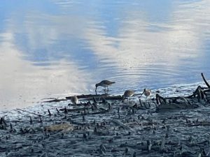
Wiley Slough is a prime birdwatching destination in Skagit County with over 232 species and counting according to e-bird, a popular, crowd-sourced app used for the identification of birds.
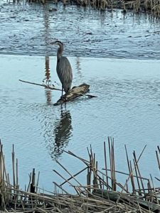
Walking the main trail beginning at the Headquarters Unit near the main parking lot, several species of shorebirds may be spotted. These include pairs of northern shoveler ducks, flickers and yellowlegs. Marsh hawks are known to fly overhead and when the tide is low great blue herons dot the sandy banks searching for dinner. Near the middle of the wetland, there is a prominent eagles nest all year round, very often with one of the nesting pairs sitting inside.
The main trail is easily accessible for all abilities including wheelchair access. It meanders along the top of the dike making for a flat and even path, although there can be a bit of gravel. This main trail is about 1.3 miles in length and forks about halfway along. The spur to the right takes you a little further into the marshes of the South Fork of the Skagit River. Sections of this trail become overgrown and muddy creating a less than desirable walk for anyone with disabilities. But if this is your chosen path, you will not be disappointed with the vast scenery and stillness which surrounds you as you approach the opening to Skagit Bay. Keep a lookout for red-wing blackbirds or even a golden eagle standing sentinel on a log surveying the marshy fields.
A pro tip: It’s always best to check tide table before heading out. A low tide is helpful, especially when birdwatching or for photographing some of this area’s most beautiful shorebirds or migratory flocks in action. Many of the bird’s flock to these marshy banks to hunt for dinner when the water table is at its lowest.
Wiley Slough Restoration Project
Restoration of this 185-acre estuary began in 2008 with much of its completion in 2010. The project aimed to restore tidal flow and fish access, primarily for the Chinook salmon, to these wetlands. In improving the Chinook salmon run, dikes around the perimeter of the wetland needed to be moved further inland to create a larger area for the young fish to spend time acclimating their bodies before heading out into the big water of the Salish Sea and beyond.
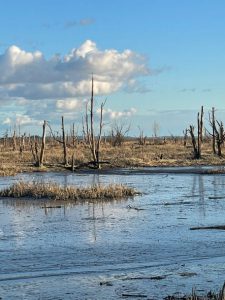
The goal of this project was to create a self-sustaining ecosystem which in turn supports natural fish, wildlife and vegetation commonly found in estuary habitats of this area.
By taking a walk in this wild place you begin to realize this vision has become a reality. A reality to preserve long into the future for generations to come.
How To Get to Wiley Slough
Take Interstate-5 to Exit 221 or the Conway exit. Head west from the freeway and follow the signs onto Fir Island Road. In approximately 1.8 miles turn left onto Wylie Road and follow for 1 mile until there is a T intersection. There will be a Washington Department of Fish and Wildlife sign visible. Just beyond this are and the T intersection follow the curve of the road to the left and watch for signs to either of the two parking lots.
The parking area to the right is generally the most accessible. In addition, there is a boat launch near the second parking lot.
Bring your camera and binoculars. A Discover Pass is required for parking.


