The North Cascades are a gorgeous portion of a spectacular mountain range. The name is so common, though, that we often overlook its origins. It wasn’t until well into my adult life that I realized the name refers to the water cascading down from glaciers, snow packs, and rain to lower elevations. Once you’ve recognized this, however, it’s easy to notice how common these features are. From large 80 foot drops to smaller cascades that allow you to cool off in the heat of the summer, beauty abounds. Here are just a few places where you can find waterfalls on hikes in Skagit County.
 Happy Creek Nature Trail
Happy Creek provides great options for people of all ability levels. A short, ADA accessible loop trail connects to a slightly longer spur to see the falls. Because the entire loop is short, diverse groups can split up without having to feel rushed or abandoned. The trail is just past the towns of Diablo and Newhalem, roughly 60 miles East of Burlington.
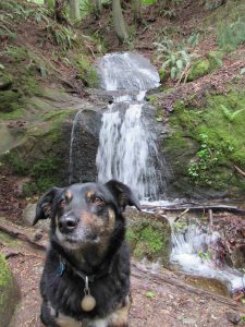
Starting from the trailhead on Highway 20 between mile markers 134 and 135, the main trail is less than a half mile and takes you along Happy Creek. This offers a pleasant walk in the shade that is good for hikers of all ages. If you want to get to the falls, however, you’ll have to work a bit more. A junction halfway through the loop takes you another mile on rocky and sometimes steep terrain up to a lovely waterfall.
If you’re hoping to see the falls when they’re most active, aim for spring or fall. The dry summer months can reduce the flow to a mere trickle. When the snow is melting and the rain is falling, though, the falls offer a picturesque, multi-layered torrent of water. Adventurous hikers can get very close to the falls, but be careful as slippery rocks can be tricky to navigate.

Ross Dam Trail
Another hike on Highway 20, Ross Dam Trail is just before Happy Creek Trail and offers a longer jaunt to the north if you’d like. However, if you just want to see the falls, it can be quite short. Starting from the trailhead, you quickly drop down and arrive at a lovely falls before even arriving at the dam. Just off the trail, the waterfall is easily accessible and there are small pools to help cool off if you’re starting or ending a long summer day.
From here you can continue on in a number of different directions. If you just want to make it a day hike, you can continue on for a few miles and see stunning views of the valley below. If you want to be adventurous, though, you can get a backcountry permit and make your way to one or more of several camp sites in the area. The trail leads to nearby peaks as well, so options abound.
Monogram Lake
Maybe the most physically demanding of these three options is Monogram Lake. Take Cascade River Road out of Marblemount to access the trailhead and prepare to climb. The trail starts with moderate switchbacks, but within the first mile becomes intensely steep. After about two miles, you mercifully reach a split in the trail. Continue right to Monogram Lake or left to a lookout.

Again, options are plentiful. If you plan to stay overnight (be sure to reserve a site) you could drop your pack, go to the lookout, and then make your way back to the lake. This is ambitious, though, and I prefer to go straight to the lake. The next two miles are mostly traversing so it’s not nearly as strenuous. Wild blueberries are abundant and provide good snacks for your break.
When you reach the lake, you’ll see signs pointing to two campsites. The first one is also how you access the falls. Heading southeast down the hill the lake drains out and cascades down majestically through the forest. This waterfall takes some work, but it’s worth every drop of sweat when you finally make it. It’s also well worth taking some time to sit by the lake, or venture up to some local prominences. You’ll find plenty of places to take photos of the Cascade Range.
If you want to get more information about these or other hikes in the area, you can go to the Washington Trails Association website or contact the North Cascades National Park at 360-854-7200.


